 Dr Pip Newling reads and writes on unceded Dharawahl Country. She has published memoir and essays, including Knockabout Girl (Harper Collins, 2007).
I watched the May flooding of the Manning River from a distance, with childhood memories of rain and water and disappearing islands, of the power of a deluge running beneath my days.
Peaking at 6.40m on Thursday 22 May, this inundation of the Manning was being called a 1-in-500- year flood and reached much higher than the 1929 flood peak of 5.97m, the previous record for the highest ever flood on the river.
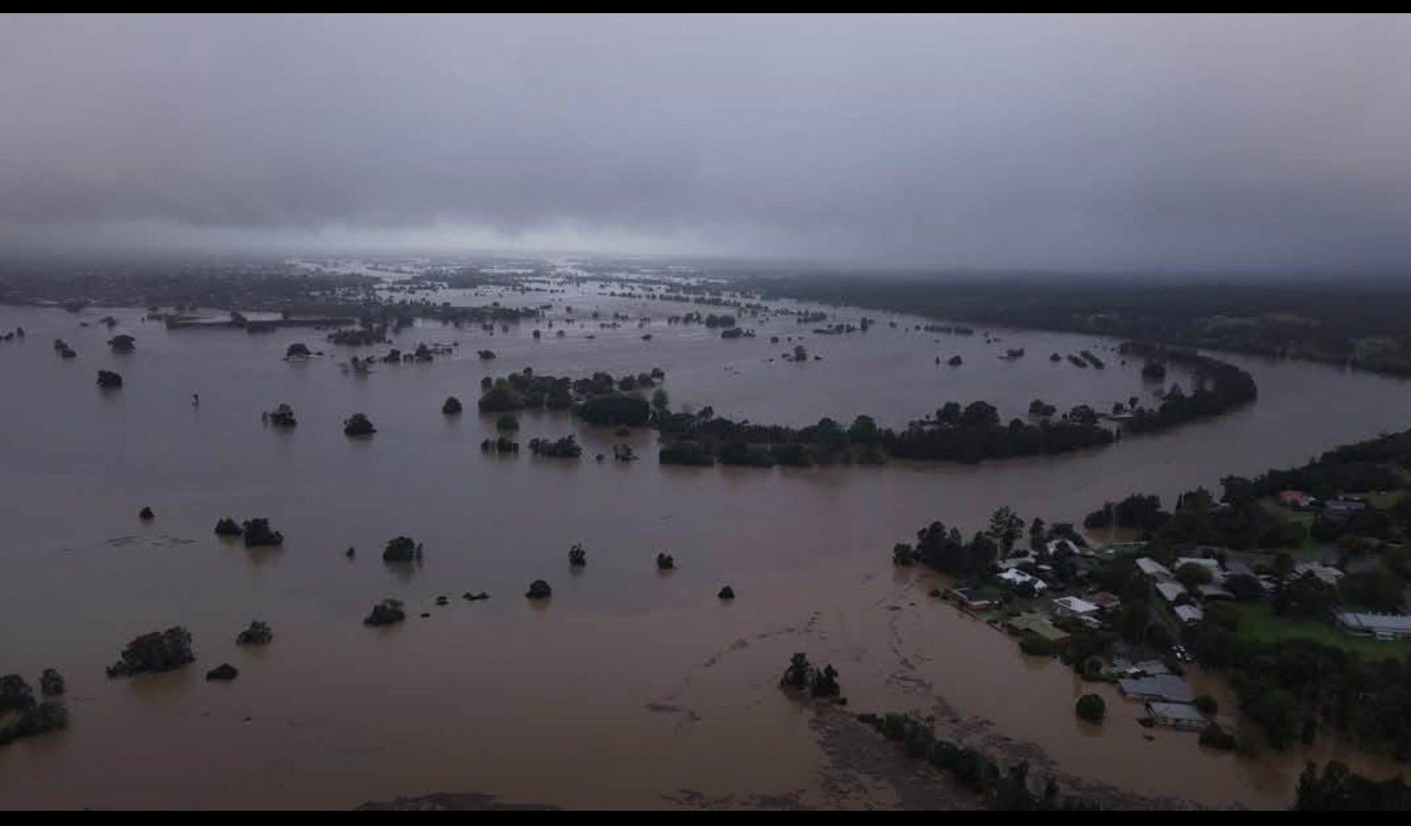
Image 1: The Manning River looking west at Tinonee, upstream
of Taree Credit: Harrison Reed (Global News), Wednesday 21 May 2025
The Lower Manning, all the river islands and alluvial rich river flats spreading out either side of the water course from Taree to the sea, was some of the earliest settled land in the Manning Valley by white settlers in the 1830s.
What these settlers saw was the constant fresh water, the rich soil replenished by flooding, and the mild weather – not too hot in summer, not too cold in winter. And the land was their’s for the taking, so they thought. These settlers appraised the land with a completely different set of visions, values and desires to the Biripi people they met as they cut down trees, re-routed water drainage across the land, changing water tables and flows, and brought cattle, sheep and fences to the district.
These settlers knew they could make livelihoods and legacy out of the land, straightforwardly and consistently, by transplanting their farming knowledge from Scotland and England. Floods, fires, drought were just another part of doing business. They prayed for – imagined – good seasons, many children and longevity.
The Manning River is a ‘double delta’ river, with two mouths to the Tasman Sea. The northern mouth lies between Manning Point and Harrington and the southern sits at Farquhar Inlet at the end of the white strip of sand of the ‘Old Bar’.
It has a very long history of floods.
The 1840 flood was the first big one recorded by white settlers, ‘A very heavy flood occurred in 1840, which converted the flats into one great one.’(1)
The next flood of note was in 1866.
But by 1866, there were well over 3,000 people in the Lower Manning, blacksmiths, boat builders, shopkeepers, postmasters, clergymen from various Churches, and schoolteachers, all calling Taree home. The impact of this flood was much more significant on humans, property and communities.
Many of these people were the first climate refugees to arrive in the Valley. They travelled across the world from Scotland, due to a string of challenging weather seasons, to settle in the Hunter Valley around Newcastle. They established dairy farms and grew crops, and then, what we now refer to as La Niña, brought a string of wet years from 1860. Switching to an El Niño event in 1864, bringing drought conditions, many settlers moved again, to the Manning.
Our contemporary communities are much more aware of these swings and patterns in weather, or at least their nomenclature, but we seem unable to imagine the worsening and compounding of severity and impact these forces bring due to a warming planet. Or acknowledge the practices that increase the warming.
The 1866 flood was a mid-winter flood that began with a rainstorm across the valley from the mountains to the sea with gale force winds uprooting trees and damaging building on top of the destruction of the crops, stock and houses swept out to sea. The ‘islands in the lower valleys were all but submerged and Cundle Plains was a ‘sea of water’.(2) Peaking over night on Friday 13 July, the river rose quickly and powerfully. In nine hours the water rose twenty feet.(3) Over 6 metres in metric.
Rivers with multiple natural mouths are rare. The only other river in the world with two naturally occurring mouths is the River Nile. New settlers on the river in 1866, didn’t believe that Mitchell Island was an island until the Farquhar Inlet, the southern mouth, ‘broke open’ during the flood. (4) The inability to imagine the river’s full character was misguided and dangerous then and is now.
From 1867 through to 1872, there were major floods every year. This turn of events left the whole Valley, but the Lower Manning community, Taree and below in particular, feeling despondent. Horace Dean, the Editor of the Manning River News, described the mood in an editorial of 7 January 1871: ‘Swollen creeks, weedy crops, damp houses, muddy thoroughfares, delayed mails, cross house-keepers, long faced husbandsmen, wheezing children – these are again looming upon us, as if such repeated visitations were not enough to drive the best natured people like ourselves to some deed of desperation.’
Six years of floods. You would think we would remember this. That these years would have travelled down in some kind of collective memory or Valley DNA. But no. Not for the white settlers who have continued building lives, livelihoods and communities in the Manning.
The years 1927 and 1928 were hard dry years for the Valley, especially the Lower Manning where, by then, dairy farms numbered in the hundreds. The land cracked and crops withered. The droughts crippled the economy of the Valley and so, when it began to rain on Monday 18 February 1929, the relief was palpable. The days were still hot, and the humidity rose as the rain continued. One reporter wrote that, ‘Ten inches of rain have fallen since Monday afternoon to Thursday night and all the world is gay.’(5)
But the rain fell in the upper tributaries of the Manning as well, and soon the river swelled powerfully, breaking banks and taking stock, fences, wharves. By Saturday night, the mark that told the height of the 1866 flood on the Bank of NSW building in the centre of town was covered by two feet of water.
As with the current flood, people had to be rescued from Taree Estate, Glenthorne, and the islands further down stream. Two people died. There were reports of Harrington people, living at the entrance to the sea, watching stock, pigs and cows and horses, swept straight out into the Tasman Sea on a continuous torrent of swirling mud and water, haystacks, dressing tables, beds, back doors all disappearing into the churning ocean. Dumaresq Island was completely covered by water and, as the floodwaters retreated, cattle were found hanging stranded in trees along the Island’s banks.
The drought had lightened the grip the farmers had on the earth and the flood washed topsoil, and several more layers besides that, down the now widened channels of the river.
Just as now, once the waters had receded the mud was everywhere. In houses, shops, dairies, through machinery and cars. The clean up was a mammoth task. The stench was awful; it always is after a flood. Mud clings to everything and smells rotten and old as though something ancient has been vomited up by the river. The layer of mud was so great in the worst affected areas that winter crops couldn’t be planted. The silt just bakes onto the grass, killing it all.
But the Valley slowly recovered. The alluvial flats were renewed. Life by the river continued and the feats of water, escape and survival became part of the folklore of the town:
Fancy nearly a mile of telegraph line swept down through farms here. Fancy having to wrench the iron roof off to escape into a flood boat.(6)
My flood was the 1978 flood. It was the biggest in my childhood, in my living memory. In 1978 the water came all the way up to the corner of the main street, Victoria, and Pulteney Street, filling the road. Victoria Street was the Pacific Highway route then, and the road was cut, isolating Taree. Houses in Taree Estate and further down stream had water up to their ceilings. The brown swirl crept up the banks and filled the Rowing Club, the Sailing Club and spilled up into the parking areas that dotted the riverside. Rapidly rising and then edging into town, it stopped eventually at 5.45 metres on the gauge at the Martin Bridge. All of Taree Estate was flooded, as were parts of Glenthorne across the river and Dumaresq Island. The Lower Manning flood plain was flowing with water. The second mouth, Farqhuar’s Inlet at Old Bar, usually choked with sand, burst.
“It’s only from up in the air you can see it – it’s indescribable,” said the then Manning Shire President, Councillor Ray Gillogy, after taking a tour in an RAAF helicopter.(7)
My stand out memory from that flood is that the town swimming pool, built on the riverbank, was underwater, overflowing with murky brown water. It was where I spent much of my time, swimming laps, mucking around. The river had come up over the fence of the pool and swept branches of trees and rubbish and, as I remember it, a dead Guernsey cow into it. The carcass, its white patches still white, was floating on its back, four skinny legs stiff and stuck straight up in the air. It moved in the current, buffeted against the fence. ‘There’s a dead cow in the pool!’
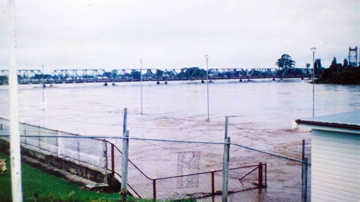
Image 2: The Manning in flood, the view from the swimming pool,
17-18 March 1978
A few years ago, I spent some time focused on Taree and the Manning Valley, working through my love-hate relationship with the place. I spoke to a great number of people about their memories and feelings about the town, the Valley, the people. Many of those conversations have remained with me. Biripi, Worimi, non-Aboriginal and newly minted residents of the Valley all shared their different relationships to the place with me.
One of those conversations sits top of mind. One Biripi Elder told me:
The river hasn’t changed… The mountains haven’t changed.
The sea hasn’t changed. There might be a new street or two,
but the river hasn’t changed. (8)
His comment chimes loudly because this history is what we know in our bones. We live by the river because we love the river, in our own way. But we whitefellas choose to embrace a forgetting, a not-knowing pretence that gets us through to the next good season.
Look at the aerial photos from May of the Manning River. See the wide swathe of milky brown water and sludge, the sweep that traces the old flood plains, the old river channels. The river remembers. This expanse and stretch and flow is what the river knows. This flood – like all the previous floods – is a flex, a forecast of what will come, of what has always been possible.
First Nations oral histories told of floods and land inundation dating back to 10,000 years, when the sea levels rose dramatically at the end of the last ice age. Correlated and supported by linguists, geographers and geologists, these stories come from communities around Australia and tell of people having to leave significant areas for higher ground due to flood.
Now in a climate emergency and collapse, it is on us to both remember and imagine. And also to listen. To learn from what has happened in this land before our times.
There is another photo from the 1978 flood of the Manning River that I have been thinking about too – it’s a photo of a fox marooned by water hanging onto to a fence post for dear life. I can’t help but think this is our current, our future status if we don’t pay attention.
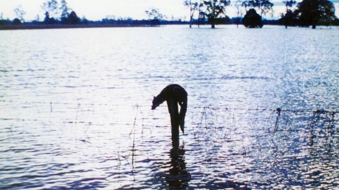
Image 3: A fox stranded in the 1978 flood,
17-18 March 1978.
I acknowledge the Biripi people of the Manning, the First Peoples of this land, and pay my respects to Elders past and present and celebrate their continual presence in the Valley. I recognise the deep knowledge and spiritual connection they have to the lands and seas on which I grew up. The Valley is unceded land and always was, always will be Aboriginal land.
(1) The Sydney Morning Herald, 9 October 1873
(2) Birrell 1987, p. 137
(3) The Wingham Chronicle and Manning River Observer, 12 February 1929 p. 3
(4) Fitzpatrick 1914, p. 119
(5) Port Macquarie News and Hastings River Advocate, 23 February 1929
(6) Port Macquarie News and Hastings River Advocate, 23 February 1929
(7) The Manning River Times, 17-18 March 1978
(8) #5, recorded interview 2012
Images:
Facebook, Thursday 22 May (credit unknown)
The Manning River Times online
The Manning River Times online
The copyright of the 1978 flood photos has been sought but no information was available. Any updates welcome.